|
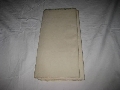
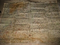
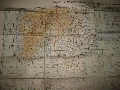
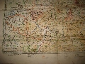
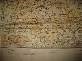
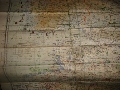
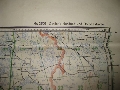
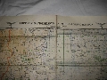
WWII German Luftwaffe Flight Navigation Map This item is WWII Original German Luftwaffe Flight Navigation Map 1940. The top edge of each side of the map has two, black printed, Luftwaffe eagles flanking the heading,"Luft-Navigationskarte in Merkatorprojektion" (Air Navigation Map in Mercator Projection), EUROPE.The map show all the topographical features such as elevations, rivers, lakes and seas and also shown are villages, towns and cities, as well as the road and rail networks. The map also has an over-printed, longitude degree markings and a repeating, square grid scale with the corresponding reference location numeral to each. The condition is perfect.
Quantity: 1
Status: available
Price: You offer
Shipping cost:
20 USD (18 EUR)
|